The Northland Walking and Cycling Strategy was developed in 2017 by Northland’s various councils, Northland Inc., the Department of Conservation, the New Zealand Transport Authority, Sport Northland, Bike Northland, and the New Zealand Outdoor Access Commission. Its aim is to contribute to the region’s economy through improved infrastructure that would attract visitors region-wide and all year round.
The strategy originally prioritised 13 trails as meeting the vision for ‘Northland as one of the world’s best coastal walking and cycling destinations where the journeys and stories are as impressive and memorable as the scenery.’ The Implementation Plan demonstrated a program for building these trails to deliver a network that could be installed in prescribed stages.
The 700 km vision
The final route for many of the trails on this map are still to be defined. For the purposes of displaying these on a map, several of the marked trails follow nearby roads.
- Blue = Underway
- Green = Already in use—enhancements proposed
- Yellow = Priority
- Red = Aspirational
Trails identified to develop initially
The following trails have been identified to be developed initially, with others added over time as use increases and resources become available. Preliminary designs and costings have been developed for each of these routes:
- Marsden Cove to Mangawhai (Bream Bay Whangarei East Coast)
- Kaihu Valley Rail Trail Stage 2 and connect with Waoku Old Coach Road (Kaipara West Coast)
- Waoku Old Coach Road to connect to Horeke and the Great Ride/Twin Coast Cycle (Kaipara and Far North West Coast)
Community-led trails
The purpose of the original strategy was to provide a strong tactical framework to support the development and implementation of district council walking and cycling strategies and to place these within a regional context by identifying actions that can be taken at a regional level. What has been highlighted in the last 3-4 years is that the 4 councils in Northland Te Tai Tokerau cannot do this on their own, and several communities have combined resources to develop trails in their local areas.
The Northland Tracks and Trails Project Team from Bike and Hike Northland supports these community groups and their local initiatives to connect the 700 km link by strategically collaborating across the groups and councils, assisting with Long Term Planning Submissions to councils, funding applications, and providing this website to allow groups to be able to share their progress and ask for help where required.
Points of interest and destinations
All trails will deliver users to points of interest and destinations across Northland Te Tai Tokerau and beyond via a network ranging from mountain bike trails to relatively flat and easy rail trails to quiet country road experiences. Users will choose interconnected routes based on their ability, preferred start and finish points, local attractions and time commitment. Ferry crossings will provide links for some of the trails, adding a dimension of interest and interaction with Northland’s coast and waterways that will broaden the appeal of the overall experience. There is also some alignment with the Te Araroa Trail – the national walking trail.
Northland’s rich cultural and environmental narratives
Northland’s rich cultural and environmental narratives are not often apparent to visitors, though local communities are often very open to sharing their stories and experiences, given the opportunity. These stories are even richer, more complex, and more compelling, requiring time and moving through Northland at a human pace (on shared pathways) to read. Implementing a layered experience of interpretative media, enhanced plantings, sculpture, heritage sites and other features will increase a sense of engagement with Northland.
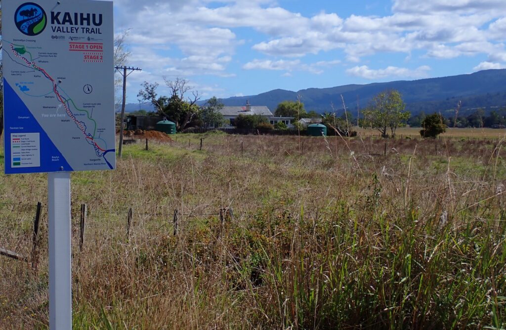
We will regularly update the progress with the overall 700 km objective and the individual trails on this site. If your trail group would like to contact us regarding your project, contact us via email:
Projects
Bream Bay Trails
The trails are outlined below, and more detail, including a map of each trail, can be viewed by clicking the link at the bottom of each summary. The Bike and Hike Northland project team is collaborating with the Whangarei District Council and the Bream Bay Trail Groups for delivery of the 87 km trails. These will connect with the Mangawhai Share Path in the South.

Marsden Cove to Ruakaka
Group: Bream Bay Shared Path
Est Distance: 5 km
Users: Cyclists / Walkers
Level: Easy
Status: Underway

Ruakaka to Waipu
Group: Collaboration bewteen Ruakaka & Waipu Community Groups
Est Distance: 13.5 km
Users: Cyclists / Walkers
Level: Easy
Status: Underway

Waipu to Waipu Cove
Group: Waipu Cycle & Walkway Group
Est Distance: 7.12 km
Users: Cyclists / Walkers
Level: Easy
Status: Operational

Waipu Cove To Langs Beach
Group: Wairahi Tracks Charitable Trust & Piroa Trails Group
Est Distance: 6 km
Users: Cyclists / Walkers
Level: Moderate
Status: In planning

Langs Beach to Mangawhai
Group: Wairahi Tracks Charitable Trust & Mangawhai Tracks Charitable Trust
Est Distance: 12 km
Users: Cyclists / Walkers
Level: Moderate
Status: Aspirational
Kaihu Valley Trail to Pou Herenga Tai—Twin Coast Trail
These projects aim to connect Dargaville to the Bay of Islands by completing Stage 2 of the Kaihu Valley Trail that will take it to Donnellys Crossing. A new trail via the Waoku Coach Road and then a connection through to Horeke at the Hokianga trailhead on the Pou Herenga Tai—Twin Coast Trail.

Kaihu Valley Trail
Group: Kaipara District Council
Est Distance: 35 km
Users: Cyclists / Walkers
Level: Moderate
Status: Stage 1 complete and in use, Stage 2 shovel-ready.

Donnelleys Crossing to Horeke
Group: To be Determined
Est Distance: 64 km
Users: Cyclists / Walkers
Level: Moderate / Advanced
Status: Aspirational
Far North District
These trails would be an extension to the Pou Herenga Tai—Twin Coast Trail offering the ride the option of including the popular and historic Bay of Islands towns of Russell, Pahia, Waitangi & Kerikeri. to their Pou Herenga Tai experience.

Opua – Russell
Group: Bay of Islands Walkway Trust
Est Distance: 7.5 km
Users: Cyclists / Walkers
Level: Moderate
Status: Underway

Waitangi – Kerikeri
Group: To be determined
Est Distance: 13.5 km
Users: Cyclists / Walker
Level: Moderate / Hard
Status: Aspirational

